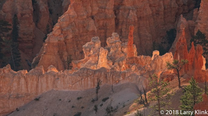
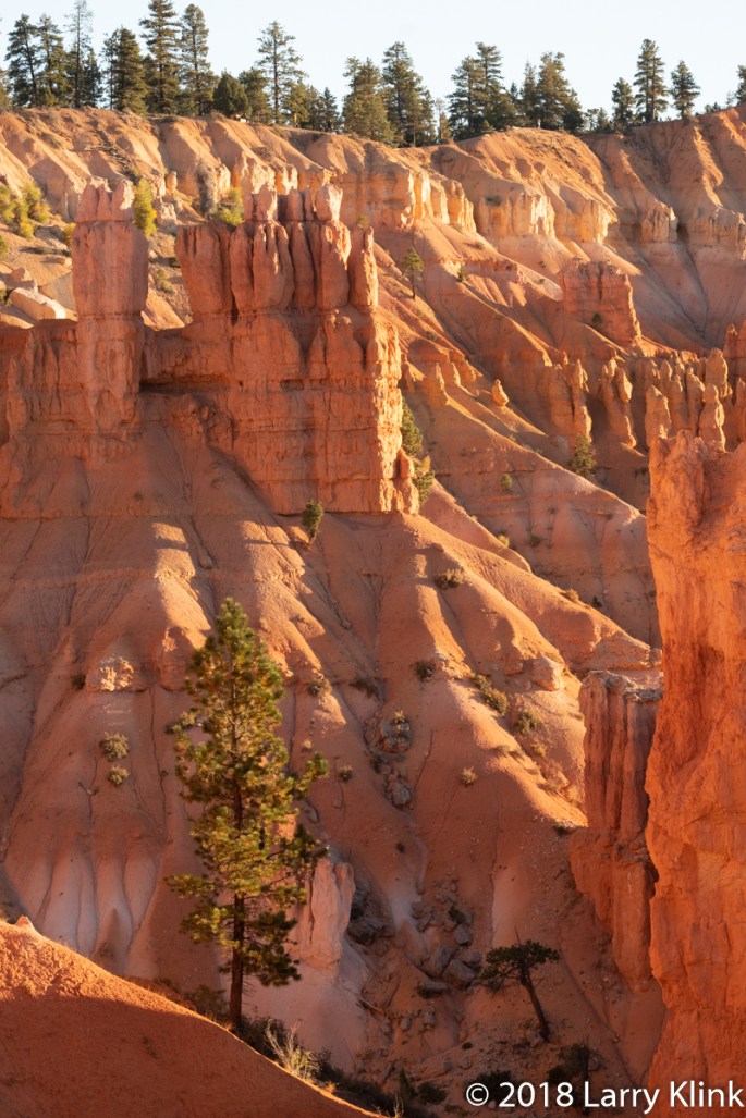
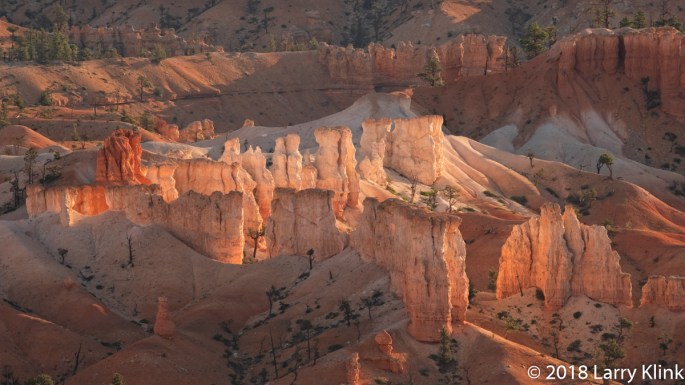
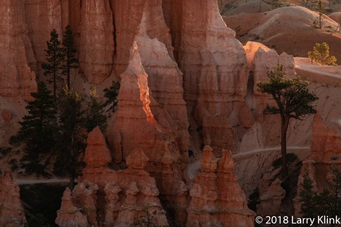
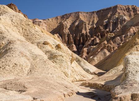
Bryce Canyon, in Utah, is stunningly beautiful; especially at sunrise and sunset. It should be on your bucket list. You can enjoy it any time of day but, I recommend being there in the morning, before the sun creeps over the distant mountains and as the sun sets in the evening. The colors saturate, the whites appear almost translucent at hose times and it will take your breath away. If you can, walk the trails that take you below the base and look at the hoodoos face on.
As I looked over the landscape, my thoughts turned to the ancient cities from fantasy and action adventures. Perhaps drawing from Petra in southern Jordan. I can imagine temples and palaces constructed from the hoodoos. I see “impregnable” walls being breached by the barbarians outside. It’s a fun connection.
For me, the process of how the land became to look as it does, enhances its beauty. In this case, water channels away the softer soil, forming the hoodoos. The freeze-thaw cycle sculpts the hoodoos by breaking off chunks. The wind helps sculpt too, but, to a lesser degree. What is left are acres of an orange and cream landscape filled with spectacular hoodoos and the erosional hills and valleys at their base.
I can’t wait to go back. Only this time, I am going to allow a day to hike and see what other treasures I uncover. I wonder what it would like in snow.
Note: Please click on caption to see higher resolution images.
Abstract art uses color, shape and line to create a pleasing image. That image may or may not represent something real. In photography, you arrive at the result through a different route. You find a candidate and create a composition that emphasizes the pattern created by the color, shape and/or line over the subject itself.
I am a primarily a landscape photographer. As I progressed and learned more about that art, I became fascinated with the questions about how a scene evolved; what processes shaped it in the past and what processes are shaping it today. As I observed, I began to see the patterns and to understand how to recognize the effects of the wind, water and tectonic events that influenced it. I also began to see how the patterns repeated themselves in different ways in different objects. It is those patterns that often make a wonderful abstract image.
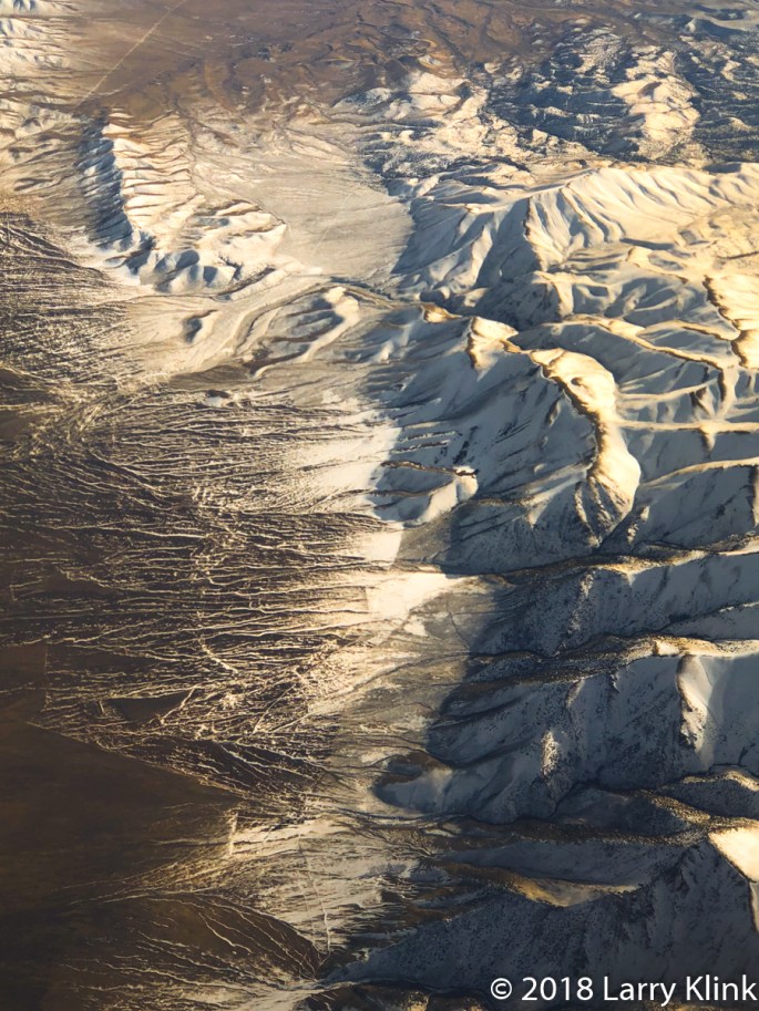
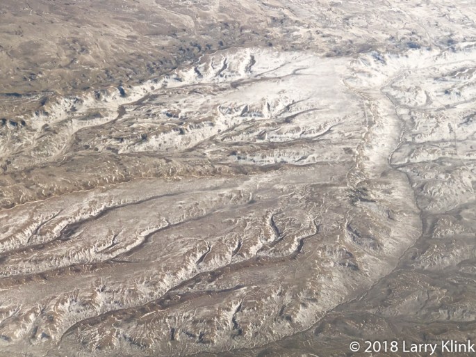
On a recent cross-country trip, we flew over the high plains of Kansas and the foothills and peaks of the Rocky Mountains. In many places the snowpack was broken; ice and snow lay in the crevices where snowmelt flows, while the remaining surfaces were clear. I was struck by the patterns that I saw. Erosion created patterns like those of a bush branching or leaves branching on a stem. In one spot, I saw a fish backbone with its tiny ribs extended. Using my trusty phone camera, through an airplane window, I created some abstracts from the landscapes I love.
I hope you enjoy these images. Reflect on the patterns – what do you see?
Regards
Larry
Note: Click on Caption to see larger, higher resolution image
We recently visited Yosemite National Park. On the day we visited, I decided to look for perspectives that aren’t commonly photographed. I love the iconic images but there are lots of nooks and crannies that provide wonderful landscapes. I hope you enjoy these images.
Regards,
Larry
Note: Click on caption to see image at larger size.
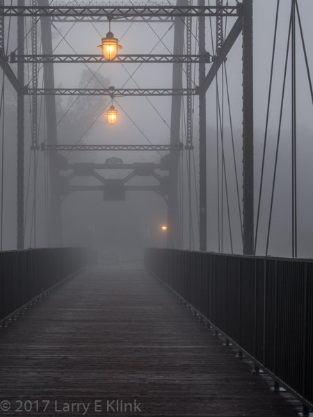
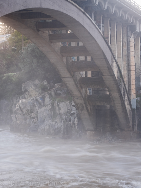
Last Friday was a cold, foggy morning and we had just come out of a long bout of heavy rain. A lot of water was being released from Folsom Lake and the American River, near Folsom was running strong. I decided to spend some time photographing the area of Folsom that surrounds the historic Walker Bridge / Donald W. Alden Memorial Bridge. It was a great time to be out. The river roared as it created whitewater through the gorge. Quite a treat. In the 5 years that I have lived in the area, I never saw significant whitewater or heard the river roar.
The Walker Bridge / Donald W. Alden Memorial Bridge was built in 1893. It was sold 3 times: once to a man in Japan who wanted it for the steel but was never able to get it, once to the State of California who dismantled it and moved it near Walker, CA to span the Klamath River, and finally back to the City of Folsom who reinstalled it on its original abutments. It now serves as a pedestrian footbridge and an access point to the American River Parkway from the City of Folsom.
I hope you enjoy these images.
Note: Click on image to see in larger size. I particularly recommend this for the image of the American Rive Gorge.
Walker Bridge / Donald W Alden Memorial Bridge, Folsom, CARainbow Bridge Arch, Folsom, CA
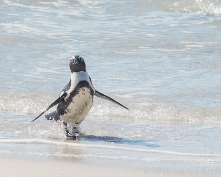
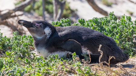
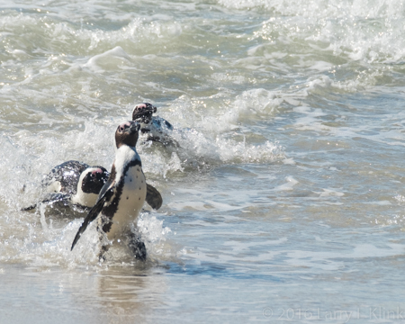
African Penguin – Perspective 2, Boulder Beach Penguin Sanctuary, Table Mountain National Park, Simon’s Town, South Africa, August 2016
The African Penguin is a species of penguin found in the waters surrounding southern Africa. It is also known as the jackass penguin because of its donkey like bray. Its numbers are declining and it is considered endangered.
South Africa has created a reserve for these penguins on Boulder Beach near Simon’s Town. There is a nice boardwalk down to the beach and an observation platform for viewing. The penguins meander around and come very close to you. They were a lot of fun to watch.
I hope you enjoy these images.
Regards,
Larry
Note: Click on individual images to see in larger size.
Black Sands Beach, Bonita Cove, Marin Headlands, Marin County, CA, FEB 2015
Almost a year and half ago, my friend Richard Bieniek took a day trip to the Marin Headlands outside of San Francisco. The Headlands are the area north and west of the Golden Gate Bridge that border on the ocean. It was a beautiful day. The sun was almost blindingly bright. The waves were tall and strong. As we walked down the steep that was path cut into the cliff side, you could hear the waves thunder before you could even see them. When we reached the small, sandy beach in the cove, the unfolding scene was remarkable. It was mid—afternoon. The sun was so bright it caused strong silvery reflections on the water. Those reflections contrasted with the deep shadows in the surrounding rock. As the waves approached, they gave the impression of a wall of water coming right at you. The scene was full of energy. Though difficult, I knew I had to share the story of what I saw.
I hope this image gives you that picture because it was wonderful to behold.
How Did I Process This Image
Those of us who shoot with a DSLR will recognize the difficulty in capturing this image. The dynamic range, the difference in exposure needed to display some detail in the shadows while not blowing away the highlights in this image is well outside the capabilities of most cameras. The obvious answer is HDR. However, that requires 3 identical images with exposures about 2 stops apart. The problem is that the ocean won’t stand still and pose long enough to make that happen. I might have chosen to blur the waves but that would have defeated one of my main objectives, to show the energy of the scene.
As you can see from the histogram in this this screenshot below, I exposed the image to minimize both the black and white clipping thus minimizing the loss of detail in both shadows and highlights. However, the digital negative is very dark. Despite many hours of trying, there was no way get a good image just manipulating the sliders and using other features of Lightroom. I had to rely on HDR. I made 3 virtual copies of the digital negative in Adobe Lightroom. I opened the exposure of 1 copy about as far as I dare; about ¾ of a stop. I made one of the others about 2 stops brighter and the other about 2 stops darker than the first. I opened the 3 copies in Photomatrix to merge them into a single HDR image. I chose the option that gave me the best, most realistic image I could find. I made a few minor tweaks and created the final HDR image. But even that created an image where the foam in the foreground churn was dark and dingy. I couldn’t open the exposure, the highlights or the whites. It would cause the ocean to blow out and lose the silvery reflection. So, I finished the image using Lightroom’s paintbrush to open the exposure on just that section of the image. I believe it worked.
My wife, brother, sister-in-law and I took a trip to the Eastern Sierra and the desert of the Great Basin. I remember a trip to Yosemite and down Rte. 395 seeing the snow capped Sierra for the first time. It was an incredible experience. In the intervening years we have experienced drought. The snow left the mountains early causing the rivers to slow early. The beauty is always there but, it’s not as spectacular as when we get lots of snow and rain. This year we got a respite from the drought so the drive down 395 regained much of its splendor. We were treated to scenes from romantic westerns; large mountain valleys, ringed with high snowcapped peaks, cattle grazing on lush green grass. I felt like I should be on a horse with Hoss and Little Joe. The rivers were running hard, churning white water that glistened in the sun. At Yosemite, the waterfalls thundered.
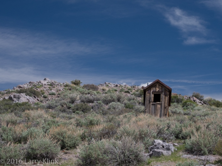
As we travel south on Rte. 395 we reach a point where the terrain transitions from mountain valleys to the valleys of the high desert. The grass goes away and is replaced by gnarled shrub. Even the vegetation along the rivers is stunted. With this year’s rain and snow, the area took on a different look. The wildflower blooms in Bodie were near their end but, stalks retained their spring green, creating a strong contrast against the brown buildings and deep blue sky.
Outhouse on a Hill, Bodie, CA, MAY 2016
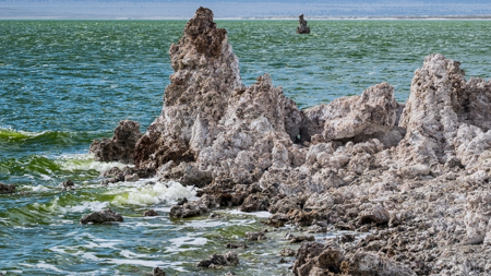
Mono Lake had a hue of emerald green instead of aqua. The lake color, along with the spring greens of its vegetation gave the tufa a softer, cooler gray color and gave a green cast to the air. The winds were very strong that day. They created white caps along with waves that crashed against the tufa and broke along the shore.
Mono Lake, South Tufa Reserve, May 2016
The strong winds followed us to the Ancient Bristlecone Pine Forest where we had planned an early morning hike along the Methuselah Trail. We had to cancel the hike because the wind chill was really bad. We hiked the shorter Discovery Trail instead. The trail was clear but snow patches dotted the adjacent hillsides. The sun peeked through openings in the overcast sky highlighting the sculptural bristlecones and the mountains in the distance.
Schullman Grove, Ancient Bristlecone Pine Forest, MAY 2016
From the bristlecones, we made our way to Death Valley. Spring was in the desert air also. Wildflowers of yellow and white were in bloom along the road. The Joshua Trees were budding but not quite ready to open. Even the cholla cactus was putting on its spring display.
My brother and sister-in-law were taken aback by Death Valley. Like me, they were raised in the eastern US. We saw deserts only in movies. They were areas where sand dunes stretched from horizon to horizon; a place where people rode camels and hung out at an oasis with palm trees. Instead, Death Valley is a typical valley in the basin and range ecosystem. It is long and narrow and ringed with high mountains. It’s hard, gray-brown soil is dotted with gnarled vegetation and rocks that washed down from the mountainsides during storms. But even it was showing signs of spring. Some of the normally dry playas contained water. Tiny wildflowers, mostly yellow, were in bloom. We hiked back Golden Canyon and we watched a sunrise at Zabriske Point. The strongly eroded mountainsides, painted by mineral deposits are always a treat to see especially under the golden sunlight of a sunrise from Zabriske.
Golden Canyon, Death Valley National Park, May 2016
We continued our journey to Lone Pine, CA. Along the way, we chuckled at 2 coyotes working the tourists at a pull-off in Panamint Valley – Will pose of food.
The Alabama Hills are located near Lone Pine. They are oddly eroded, twisted rocks, at the base of Mt Whitney. They were used as the set for many Hollywood productions of western and other adventure movies. Those of us who were fans of Roy Rogers, Gene Autrey, Hopalong Cassidy and the other cowboy protagonists of our childhood would find those hills familiar. Lone Pine also houses the Lone Pine Film History Museum. It holds memorabilia from movies produced in that area. It was fun to see the fancy saddles and guns, stagecoaches and even some monsters and space aliens. It was fun to reminisce also.
The final part of this journey took us to Yosemite. Our plans were to go across Tioga Pass but a snowfall the night before closed it. We had to detour. The detour took us on Rte. 88 from Sorenson’s to Jackson; a stretch we’ve never driven. It was a beautiful drive over granite balds, along steep sided canyons and past mountain lakes. We found a new place to explore for photo opportunities.
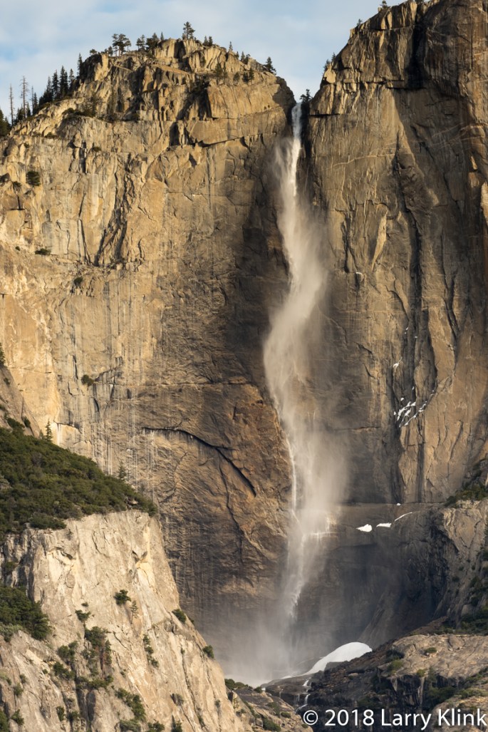
Yosemite is at its most beautiful in the spring. Waterfalls thundered, the Merced River churned white water, ephemeral waterfalls were still flowing. We were only able to visit the valley. Even Glacier Point was closed due to “impending storm”. But wondering through the valley is a joy. The immense scale, with waterfalls crashing over sheer granite cliffs towering 3,000 feet and more above your head, drive home the power and awesomeness of nature’s forces and God’s creativity. I am always awe-struck by its beauty. It never gets tiring.
Bridal Veil Falls, Yosemite National Park, May 2016
I hope my images and words give you a sense of spring in Northern California. Stay tuned for Part 2 of our adventure.
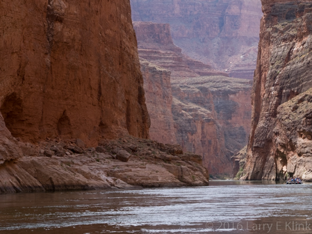
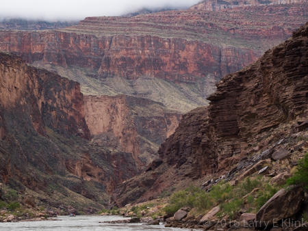
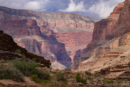
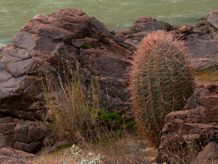
I had an amazing experience; five days rafting through the Grand Canyon on the Colorado River. Many thanks to Gary Hart (http://www.garyhartphotography.com/), who organized the trip, and to Western River Outfitters (http://www.westernriver.com/), who conducted it. Their professionalism, efficiency, and energy made the trip great fun, great adventure, and an unforgettable experience.
The trip began with a flight over the Colorado Plateau to Marble Canyon, AZ where we packed up and entered the river at a spot called Lee’s Ferry. We traveled 180 miles through Marble Canyon and the Grand Canyon. At Whitmore Wash we were helicoptered out to Bar 10 ranch then back to Las Vegas by small plane. After spending time on the river, the return flight gave me an opportunity to connect some dots: I could see the relief of the canyon and view the beds of the feeder rivers as they travelled to the slot canyons and into the Colorado. We travelled on motorized rafts that were 5 heavy duty vinyl pontoons lashed together with ropes. Each of the pontoons was about 25 feet long and 3 feet in diameter. Our food, camping gear, and personal items were piled on, covered, and tied down on 2 platforms lashed to the pontoons. We camped on sandbars along the river; some under the stars, others in tents.
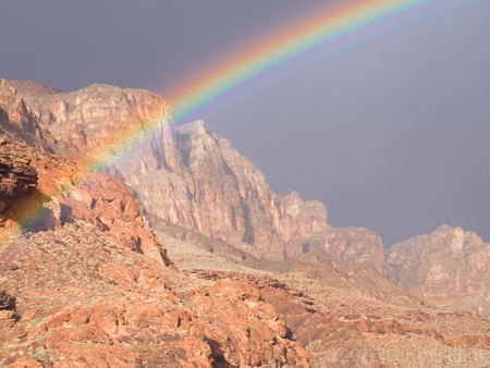
My first impression took me back to adventure stories where a team of intrepid explorers entered an unknown and unexplored area looking for the fabled lost city and its people. The narrow gorge through weathered, high walled canyons, felt imposing. The patterns on the rock reminded me of ancient statuary that weathered away. It left me wondering where the door to the ancient city, the one that is only revealed at sunset on the summer solstice, is located.
The geology was fascinating. Over the course of our trip, our elevation changed by 1,700 feet. When we entered Marble Canyon, we were between walls of the red-orange limestone layer that forms the roof top of the canyons. As we travelled through the canyon, progressively deeper layers were exposed until we came to the basement layer of granite which underlies the canyon. At places, nearly 2 billion years of earth’s history lay exposed for us to see.
To top off all of this beauty we even got to have fun running the rapids. There were many rapids. Most of them were small ripples. Two of them were really wild rides. Several more were big enough to be exciting. As we approached the rapids, you could see choppy white water ahead. The swells that had already broken smoothed out to a jello-like surface and reflected gold on top of the green river. As the driver turned the raft into the swells the swells would lift the raft and drop it down or the raft would nose dive and dig into the swell. Sometimes a wave would hit from the side. Regardless, water sprayed up, soaking us. As we held on, braving the bucking and twisting, we laughed like little kids. I was anxious about this part of the trip, not really knowing what to expect. Having done it, I wouldn’t trade the experience.
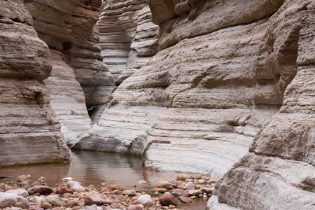
Visiting the rim or flying over the canyon will give you an appreciation of its magnificence. But running the river brings it up close and personal. Look up and see cliff walls rising thousands of feet or see the layers set back, one upon the other, rising into the sky. Look at the walls and see swirls of fossilized sand dunes or rock walls that look like layers of stacked stone; some horizontal, some tilted at an angle. Vegetation invaded the weathered red-orange limestone giving the appearance of terraced gardens. In other places cacti and brush dotted hillsides of black and brown in no particular pattern. Still other areas were painted in earth tones of tan, brown, pink and green. We hiked back slot canyons to see running streams and waterfalls that have carved the sidewalls and brought debris to the canyon floor. We were even lucky enough to see some of the wildlife that inhabits the canyon: condors flying high above, big horn sheep climbing canyon walls, swallows swooping over the rapids to catch bugs and even a heron. I have difficulty finding words to describe how it felt to be among those ancient walls. Walls that were created by the deposition of silt and the remains of creatures at the bottom of a great sea, uplifted when plates of the earth’s crust crashed into each other and finally sculpted by the forces of wind and rain into the natural wonder that was presented to me each day of the trip. Wonder and awe aren’t expressive enough.
I hope the images I’ve included give you sense of what I felt as I traveled through the natural wonder that is the Grand Canyon.
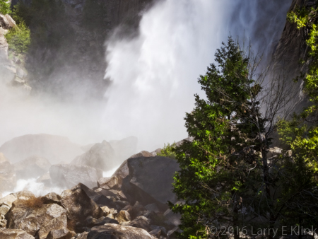
We are fortunate this year that El Niño gave us a respite from the drought; a good snow pack in the Sierra! I moved to northern California 4 ½ years ago. My wife told me many times that the ephemeral waterfalls, those that dry up and go away quickly, make Yosemite especially beautiful in early spring. But years of drought gave us little snow, leaving those falls dormant or very short lived. I never had a chance to experience them.
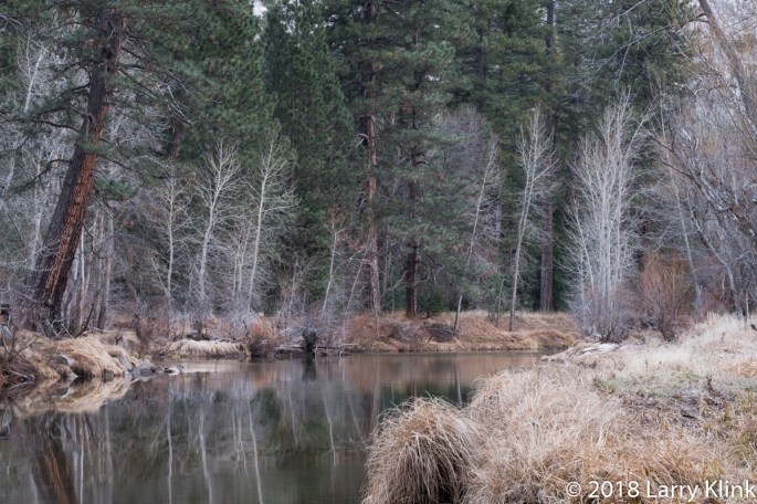
Last weekend, we took an overnight visit to Yosemite. My wife was right, everywhere I looked there was a waterfall that I had never seen before. Even Horsetail falls, the one that lights up like fire at sunset in February, was still running. The Merced River was running strongly. We hiked along the Merced River on the trail to the bridge at Vernal Falls.
At the juncture of Illouette Creek and the Merced River, the waters roiled over the cascades making whitewater that looked like a giant head of cauliflower and sounded like thunder. It was amazing.
Yet, as I traveled through Yosemite, another thought struck me. As humans, ephemeral describes things that come and go quickly; in the span of short periods within our lifetime. But, solid rock in places like Yosemite last for time frames impossible for humans to comprehend but do eventually wash away. To the earth is really ephemeral?