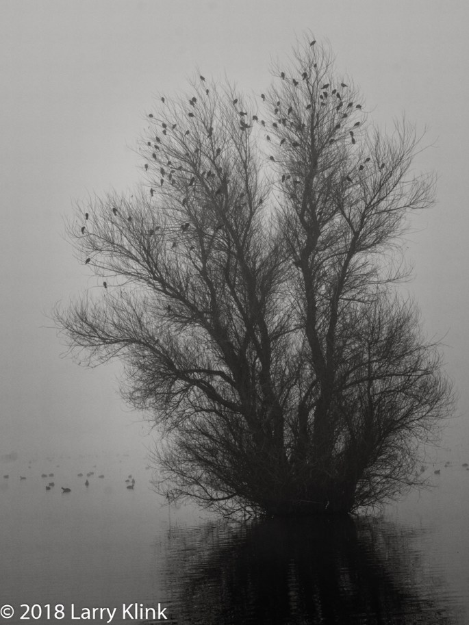
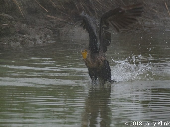
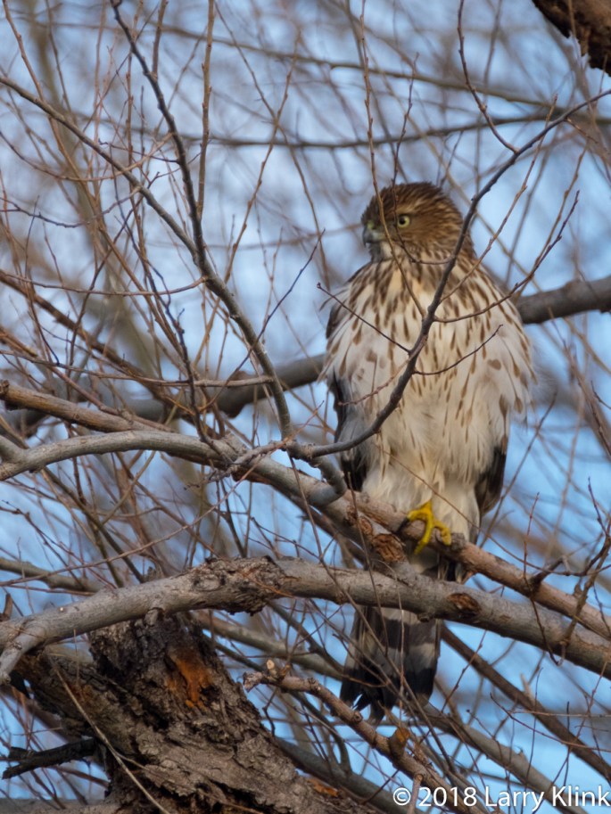
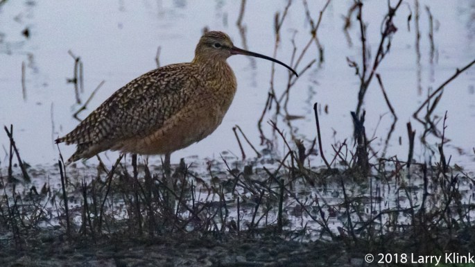
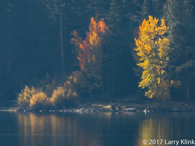
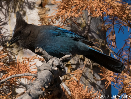
Our visit to the Sacramento and Colusa National Wildlife Refuges found us in fog an low light. These conditions make photography more difficult but also present some interesting opportunities for unique and special images. Additionally, on this visit, we were treated to some birds that we don’t normally see. I hope you enjoy these images.
Regards,
Larry
Note: Please click on caption to see image in larger size.
Politically, Iceland is considered part of Europe. Geologically, though, it is a very different situation. Iceland sits atop the mid-Atlantic ridge. The ridge is a chain of volcanic mountains, mostly under the Atlantic Ocean that stretches most of the way between the North and South Poles. It is the dividing line between the Eurasian and North American tectonic plates. As the volcanos erupt, the lava causes the Atlantic Ocean to become wider, pushing North and South America westward and Europe and Africa eastward.
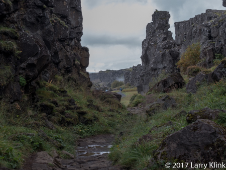
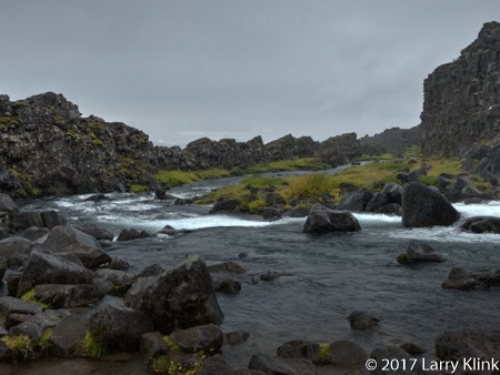
The Almannagjá Ravine is a crack or rift between the North American and Eurasian plates that is located in Þingvellir National Park It is a small part of the section of the mid-Atlantic ridge that runs northeast to southwest through Iceland. It geologically, marks the boundary between Europe and North America.
These images were taken in the Almannagjá Ravine. As you look at them, the walls to the left are in Europe and those on the right are in North America. For geology geeks like my wife and I, it is truly amazing to be able to stand on the mid-Atlantic ridge and to be able to walk between Europe and North America.
In 930, Iceland established its parliament in Þingvellir, near this location. Sessions were held there until 1800.
I hope you enjoy these images.
Regards,
Larry
Note: Click on caption to see images in higher resolution and larger size.
When I close my eyes and picture Iceland, I think of coastal plains lying between the ocean and tall cliff sides. At some places, the plains are grass covered, at other places they are filled with jagged black lava. The cliff sides are impressively tall and massive. They are green with vegetation and filled with outcrops of volcanic basalt. All along the cliff sides, waterfalls appear at frequent intervals. Free range sheep, in small groups, dot the hillsides. Oceanside beaches are black from the volcanic rock and sand.
Glacier melt from the ice covered volcanic mountains creates many, many small streams. These streams drop in long thin ribbons of white from the cliffside. Where they hit the plain, they cut small streams that meander their way to the oceans. In September, the streams flow through gullies in their rocky beds. But, I am told, that in the spring the beds are full of raging water. The streams travel short distances so they don’t have time to merge into large rivers. Despite their size, the fall from glacier to ocean gives them a swift current.
The plains are used for ranching. A few ranchers have cattle but most raise sheep and horses. Icelandic wool products are sold throughout the country. Lamb is a staple; Icelandic meat soup is very good.
There are also many horses which are unique to Iceland. They are short, stalky beasts with long, shaggy mains and tails. There is little farming. In fact, we saw only one garden at a home behind a place where we stayed.
Iceland has a history of recent volcanic activity. So, the rocks are angular and jagged. They haven’t had time to weather into smoother surfaces. But, even in the lava fields, grasses and wildflowers grow between the rocks and gravel. Moss sometimes grows on the volcanic rock giving the lava fields a soft, velvety green color to contrast with its normal black, jagged features.
As you travel through Iceland, you get glimpses of the massive glaciers that cover many of the mountains. In a few spots, glacial tongues reach the valley floor. Where this occurs, you can see the blue icy edges of the glacier. At the edge, ice breaks loose and falls as icebergs into lagoons. In Jökulsárlón, the icebergs float down a short river and into the ocean where some flow back onto beach.
We got to spend precious few hours in the highlands (mountains). One visit took us across a rocky riverbed of gray-green volcanic rock into hills made of broken shards of shale. Shale is sedimentary rock meaning it formed under a calm lake or ocean. It is an anomaly in an otherwise volcanic landscape. A second trip took us to a high valley near one of the glaciers. The valley is reminiscent of those you might see in a medieval fantasy story. The path through the jagged rocks of the tall valley led uphill, next to a stream that cascades from the glacier. The atmosphere was cool and damp. The cliff side was covered with moss and wildflowers.
I’ll be publishing more images focused on different features. Iceland is a remarkably beautiful place. I look forward to visiting again.
Note: Click on caption to see images in a larger size.
On August 1st, Welcome Books released Lighthouses of America. I am pleased to announce that 2 of my images, St Augustine Lighthouse, FL and Point Arena Lighthouse, CA were included in this great book. Please check it out.
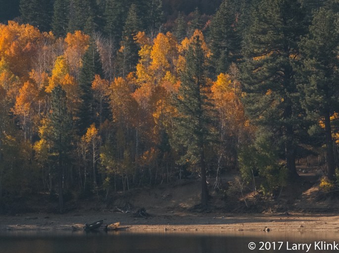
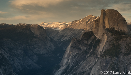
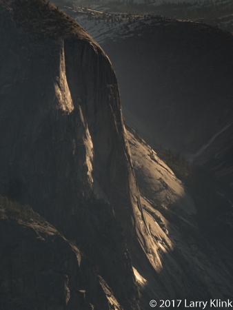
A few weeks ago, we spent an evening and early morning at Yosemite. Water was running everywhere. The Merced River was a raging snake of whitewater. The granite cliffs of Yosemite are amazing anytime but, when they are covered with ribbons of water falling 3,000 feet, it is really amazing.
I hope you enjoy these images.
Regards,
Larry
Note: Click on caption to see image at larger size.
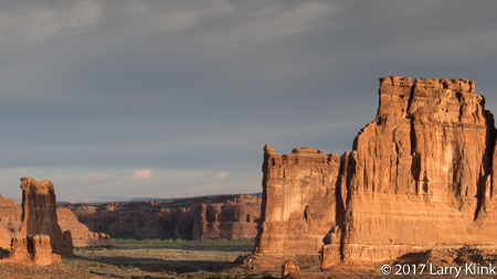
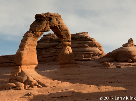
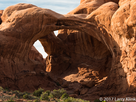
We took a day on our road trip and spent it at Arches National Park. During an evening and a morning, you can see many of the main attractions but there is a lot to see that require short to moderate hikes. I hope to go back and spend a few days hiking.
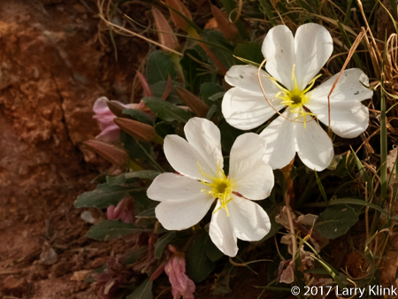
The park is located over a geologically unstable salt bed. The movement of the salt bed and the earth’s tectonic forces caused large blocks of sandstone to uplift. Over millions of years, the sandstone eroded forming the arches and rock monoliths we see today. The park service claims more than 2,000 arches; some just a 3 foot opening through a mountain to the largest: 306 feet base to base. There are massive stone walls whose size, shapes and eroded faces bring pagan temples to mind. There were lots of wildflowers and some wildlife.
I left thinking that I’d like to spend time watching the sun, moon and stars rise and set over these geologic wonders. To me, it is a spiritual place. Our mistake was not giving ourselves the time to take in the spirit.
Please click on caption to see image at a larger size.
Regards,
On a recent road trip, we stopped by the Petrified Forest National Park. It was another of the amazing wonders that are our National Parks. Sitting among the beautiful desert landscape are remnants of trees that thrived 200 to 225 million years ago. What we see today is not the tree itself, it is a fossil. The living cells have long since decayed and been replaced by silica, calcite, pyrite, or another inorganic material such as opal. What is fascinating is that the remains look like sections from a tree; including the bark. The result is a stunning fossil rich in color. The park is near Holbrook, AZ, not far off I-40. A casual tourist can get a good view of the park in a few hours. I am looking forward to returning for a few days to enjoy the trails and do some more photography.
I hope you enjoy these images. Please click on caption to see image in larger size.
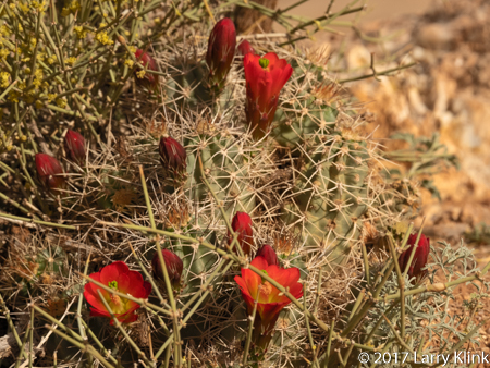
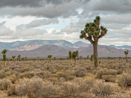
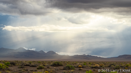
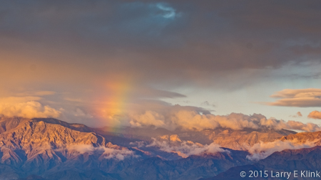
In October, 2015, Donna and I made a tour of the Great Basin area in Nevada. I recently revisited the images I took during that trip and decided to get them ready to publish. The first image is of a special Joshua Tree forest. It is special because, over the mountains,behind the forest, lies Groom Lake, the fabled Area 51. I wonder what you’d see if you were a bug on one of the trees. The second image is of a rainstorm over the desert. It is raining in the distance as crepuscular rays cast their beams over the desert landscape. The third image is a rainbow over Death Valley. I’ve published a version of this image before but wasn’t happy with it. Now it’s back and will be one of the images featured in my show at ACAI Gallery and Studios beginning December 17. The fourth image is one of Mesquite Dunes in Death Valley. It too will be displayed in my show.
Clouds, Sun and RainWondrous MorningSun Setting Over Mesquite Dunes – Perspective 1
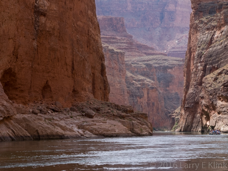
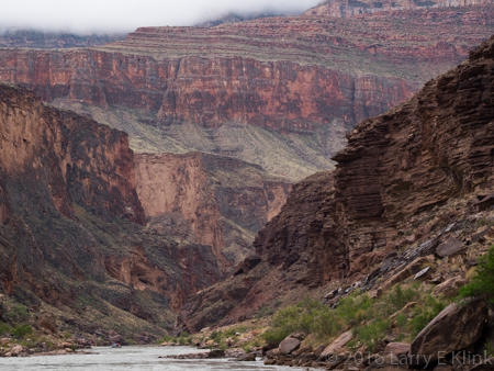
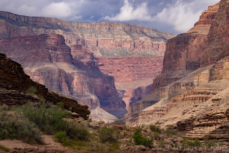
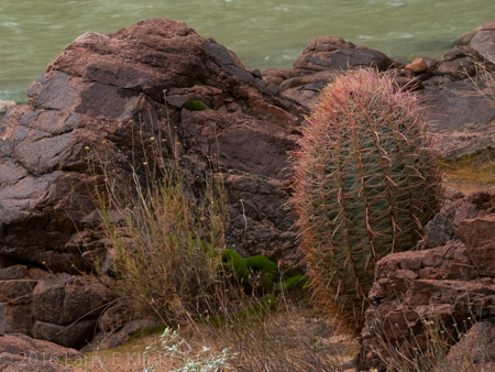
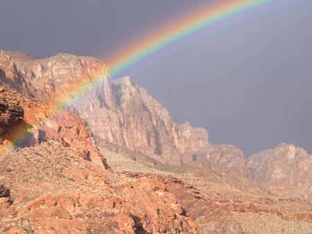
I had an amazing experience; five days rafting through the Grand Canyon on the Colorado River. Many thanks to Gary Hart (http://www.garyhartphotography.com/), who organized the trip, and to Western River Outfitters (http://www.westernriver.com/), who conducted it. Their professionalism, efficiency, and energy made the trip great fun, great adventure, and an unforgettable experience.
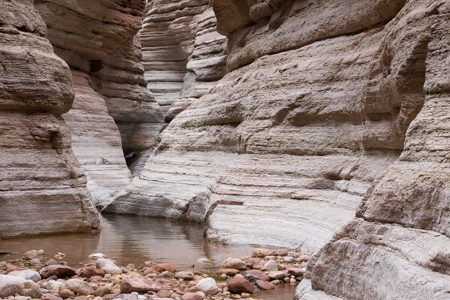
The trip began with a flight over the Colorado Plateau to Marble Canyon, AZ where we packed up and entered the river at a spot called Lee’s Ferry. We traveled 180 miles through Marble Canyon and the Grand Canyon. At Whitmore Wash we were helicoptered out to Bar 10 ranch then back to Las Vegas by small plane. After spending time on the river, the return flight gave me an opportunity to connect some dots: I could see the relief of the canyon and view the beds of the feeder rivers as they travelled to the slot canyons and into the Colorado. We travelled on motorized rafts that were 5 heavy duty vinyl pontoons lashed together with ropes. Each of the pontoons was about 25 feet long and 3 feet in diameter. Our food, camping gear, and personal items were piled on, covered, and tied down on 2 platforms lashed to the pontoons. We camped on sandbars along the river; some under the stars, others in tents.
My first impression took me back to adventure stories where a team of intrepid explorers entered an unknown and unexplored area looking for the fabled lost city and its people. The narrow gorge through weathered, high walled canyons, felt imposing. The patterns on the rock reminded me of ancient statuary that weathered away. It left me wondering where the door to the ancient city, the one that is only revealed at sunset on the summer solstice, is located.
The geology was fascinating. Over the course of our trip, our elevation changed by 1,700 feet. When we entered Marble Canyon, we were between walls of the red-orange limestone layer that forms the roof top of the canyons. As we travelled through the canyon, progressively deeper layers were exposed until we came to the basement layer of granite which underlies the canyon. At places, nearly 2 billion years of earth’s history lay exposed for us to see.
To top off all of this beauty we even got to have fun running the rapids. There were many rapids. Most of them were small ripples. Two of them were really wild rides. Several more were big enough to be exciting. As we approached the rapids, you could see choppy white water ahead. The swells that had already broken smoothed out to a jello-like surface and reflected gold on top of the green river. As the driver turned the raft into the swells the swells would lift the raft and drop it down or the raft would nose dive and dig into the swell. Sometimes a wave would hit from the side. Regardless, water sprayed up, soaking us. As we held on, braving the bucking and twisting, we laughed like little kids. I was anxious about this part of the trip, not really knowing what to expect. Having done it, I wouldn’t trade the experience.
Visiting the rim or flying over the canyon will give you an appreciation of its magnificence. But running the river brings it up close and personal. Look up and see cliff walls rising thousands of feet or see the layers set back, one upon the other, rising into the sky. Look at the walls and see swirls of fossilized sand dunes or rock walls that look like layers of stacked stone; some horizontal, some tilted at an angle. Vegetation invaded the weathered red-orange limestone giving the appearance of terraced gardens. In other places cacti and brush dotted hillsides of black and brown in no particular pattern. Still other areas were painted in earth tones of tan, brown, pink and green. We hiked back slot canyons to see running streams and waterfalls that have carved the sidewalls and brought debris to the canyon floor. We were even lucky enough to see some of the wildlife that inhabits the canyon: condors flying high above, big horn sheep climbing canyon walls, swallows swooping over the rapids to catch bugs and even a heron. I have difficulty finding words to describe how it felt to be among those ancient walls. Walls that were created by the deposition of silt and the remains of creatures at the bottom of a great sea, uplifted when plates of the earth’s crust crashed into each other and finally sculpted by the forces of wind and rain into the natural wonder that was presented to me each day of the trip. Wonder and awe aren’t expressive enough.
I hope the images I’ve included give you sense of what I felt as I traveled through the natural wonder that is the Grand Canyon.