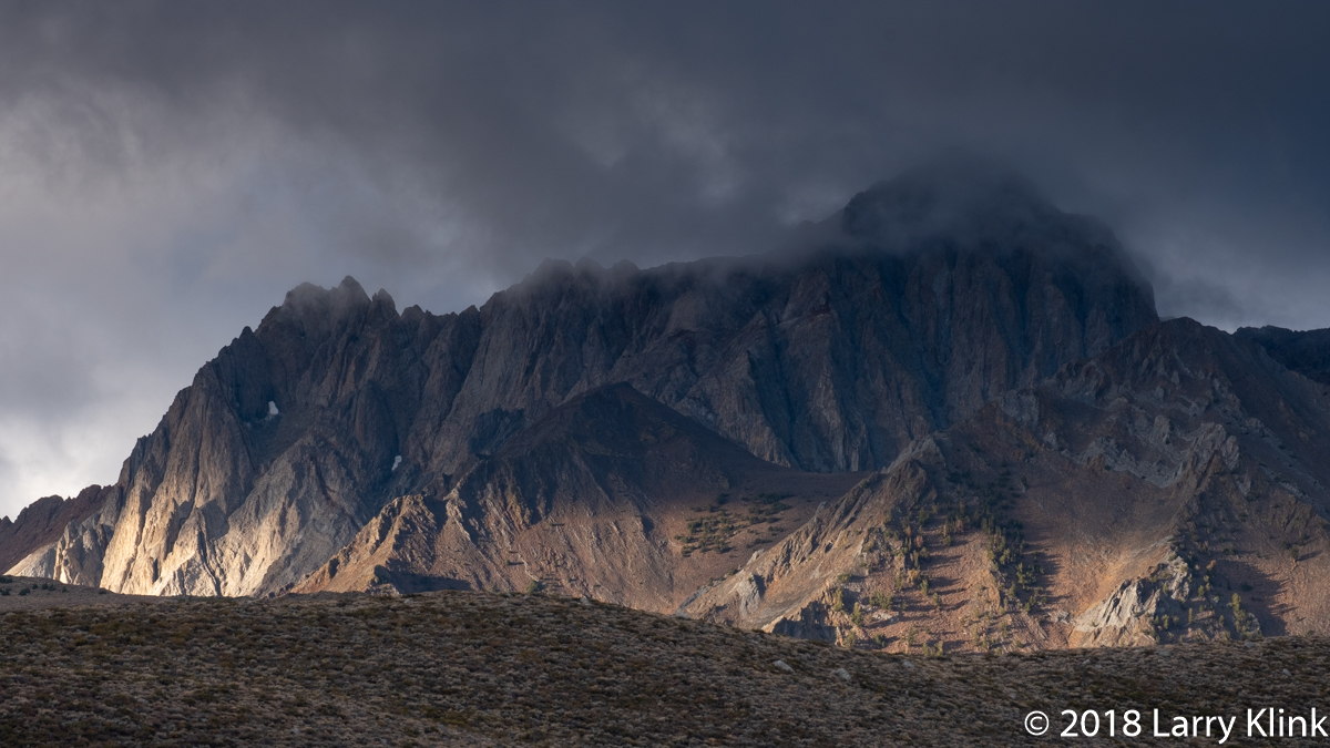
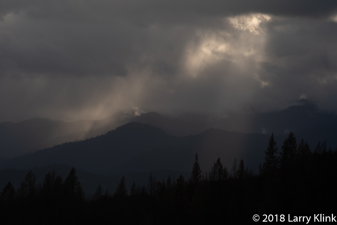
Birds Around A Local Pond

Hooded Mergansers
Hooded Mergansers

I regularly take long walks at different sections of the American River Parkway between Folsom and Fair Oaks. At one spot, along Lake Notomas, there is a small pond tucked back but alongside the bike trail. I never know what I am going to find. Last week, I was treated to what is a rare site to me – some hooded mergansers. Their cousins, the common mergansers, stick around all year. I often see belted kingfishers and acorn woodpeckers in that area also.

Acorn Woodpeckers are ubiquitous in this area. For those of you who aren’t familiar with them, their behavior is different from most other woodpeckers. They find acorns and pound them into holes in dead trees. When they can’t find a hole, they make one. Later, they come back and eat them – if the squirrels and other wildlife don’t get them first.

Regards,

Larry

Please click on caption to see image at higher resolution

Acorn Woodpecker
Acorn Woodpecker
Male Belted Kingfisher
Belted Kingfisher
Female Hooded Mergansers
Acorn Woodpecker
Acorn Woodpecker

Note: These and other images are available to purchase on my website: www.earthwatcher.us or by contacting larry@earthwatcher.us.


Autumn In The Eastern Sierra

Scene from McGee Creek Rd
Scene from McGee Creek Road

A few weeks ago, we took a trip to the eastern side of the Sierra Nevada, along route 395 from the junction of Rt 89 to Bishop, CA. Generally, we wanted to enjoy the autumn foliage. But we also wanted to explore Buttermilk County, the area along Buttermilk Road near Bishop. We did all of that and managed to include a drive into McGee Creek Canyon. The rabbitbrush was in bloom. Aspens and other trees were displaying the finest golds and oranges. It was a wonderful trip into the mountains.

Note: Please click on see images at higher resolution.

Aspens Below Dunderburg Mountain
Aspens Below Dunderberg Mountain
Stormy Sunrise from Mt Morrison Rd
Stormy Sunrise from Mt Morrison Road
West Fork, Carson River
Scene from Buttermilk Rd - P4
Scene from Buttermilk Road – P4
Owens Valley from Buttermilk Rd
Scene from Buttermilk Rd - P1
Scene from Buttermilk Rd – P1

These and other images are available to purchase on my website www.earthwatcher.us or by contacting larry@earthwatcher.us

Some Wildlife from Recent Trips

Black Bear
Black Bear, Markleeville, CA

Here is a few shots of some wildlife we saw travelling through various places. The locations are listed with each image.

We hadn’t seen any bears in the wild for several years. Then, on one trip, we saw 2. Unfortunately, the one that got away, was a cinnamon colored one. Maybe someday I’ll be able to photograph one of those.

The tufa in Mono Lake are beautiful themselves but we got a rare treat – an osprey on its nest on top of a tufa.

Note: Click on caption to see image at higher resolution.


Grand Prismatic Spring

Grand Prismatic Spring, Yellowstone National Park; SEP 2018
Grand Prismatic Spring – P4

The Grand Prismatic Spring is another of Yellowstone’s iconic hydrothermal features. It is the one that looks like a big orange and blue eye. The spring sits along the Firehole River in the general area of the Upper Geyser Basin where Old Faithful resides. It produces a constant flow of water that flows into and heats the Firehole River. To me, the Firehole River is the most fascinating of Yellowstone’s rivers. It flows from Madison Lake, on the continental divide, 21 miles to the Gibbon River at Madison Junction. What fascinates me, is that it travels through the Upper Geyser Basin, where Old Faithful is located, and past the Grand Prismatic Spring. Those and other hydrothermal features dump their water into the Firehole. This raises the temperature 9-18 degrees Fahrenheit.

The pool filled by the Grand Prismatic Spring is very shallow. It is colored by the brown. orange and yellow bacteria and algae that grow in its pool. The sun highlights its colored features and the water reflects the blue of the sky. Steam rising from the spring adds mystery to the landscape. Though you can appreciate the spring by just giving it a cursory walk-by, paying attention to the details and seeing how the light seems to make them change provides a breathtaking experience.

Here is a link to an image that shows the spring in totality: https://www.gettyimages.com/detail/photo/grand-prismatic-spring-close-up-royalty-free-image/136952950; I don’t have one of my own to share.

Note: Click on caption to see higher resolution image.

Grand Prismatic Spring, Yellowstone National Park; SEP 2018
Grand Prismatic Spring – P8
Pine Cone in a Hot Spring
Edge of Excelsior Geyser
Grand Prismatic Spring, Yellowstone National Park; SEP 2018
Grand Prismatic Spring – P10
Grand Prismatic Spring, Yellowstone National Park; SEP 2018
Grand Prismatic Spring – P6
Edge of Excelsior Geyser -P2
Edge of Excelsior Geyser – P2
Grand Prismatic Spring, Yellowstone National Park; SEP 2018
Grand Prismatic Geyser – P1
Overflow Into the Firehole River - P2
Overflow Into The Firehole River – P2
Grand Prismatic Spring, Yellowstone National Park; SEP 2018
Grand Prismatic Spring – P7
Overflow Into the Firehole River

Note: These and other images are available to purchase on my website: www.earthwatcher.us or by contacting larry@earthwatcher.us.

Bryce Canyon

The Ancient City
The Ancient City

Bryce Canyon, in Utah, is stunningly beautiful; especially at sunrise and sunset. It should be on your bucket list. You can enjoy it any time of day but, I recommend being there in the morning, before the sun creeps over the distant mountains and as the sun sets in the evening. The colors saturate, the whites appear almost translucent at hose times and it will take your breath away. If you can, walk the trails that take you below the base and look at the hoodoos face on.

As I looked over the landscape, my thoughts turned to the ancient cities from fantasy and action adventures. Perhaps drawing from Petra in southern Jordan. I can imagine temples and palaces constructed from the hoodoos. I see “impregnable” walls being breached by the barbarians outside. It’s a fun connection.

For me, the process of how the land became to look as it does, enhances its beauty. In this case, water channels away the softer soil, forming the hoodoos. The freeze-thaw cycle sculpts the hoodoos by breaking off chunks. The wind helps sculpt too, but, to a lesser degree. What is left are acres of an orange and cream landscape filled with spectacular hoodoos and the erosional hills and valleys at their base.

I can’t wait to go back. Only this time, I am going to allow a day to hike and see what other treasures I uncover. I wonder what it would like in snow.

Note: Please click on caption to see higher resolution images.

Sunrise at Inspiration Point
Bryce Canyon - P4
Bryce Canyon – P4
Castle on a Hill
Castle on a Hill
Bryce Canyon - P3
Bryce Canyon – P3
Bryce Canyon - P2
Bryce Canyon – P2
Bryce Canyon - P5
Bryce Canyon – P5
Bryce Canyon - P7
Bryce Canyon – P7
Bryce Canyon - P10
Bryce Canyon – P10

These and other images are available to purchase at my website www.earthwatcher.us or by contacting larry@earthwatcher.us

Yellowstone Wildlife

Scene from Swan Lake Flat
Scene from Swan Lake Flats, Yellowstone National Park; SEP 2018

Yellowstone is known as much for its wildlife as its great geologic features. North America’s apex predators, the wolf, grizzly bear and the mountain lion all roam Yellowstone’s wild lands along side the bison, elk, moose, deer and other prey species. Sadly, many of the species we had hoped to see didn’t show and a few were too far away to get a good picture. But we did see some and what we saw was amazing.

In this post, you’ll see the pica, a relative of the rabbit that lives in higher altitude rock fields. You’ll see the pronghorn which is related to but is not an antelope and the mountain goat which is not a goat but, an antelope. Finally, the American Dipper; the only North American song bird that feeds underwater in stream beds.

The Swainson’s hawks we taken not far outside of Idaho Falls, ID on the last leg of our journey to Yellowstone.

I hope you enjoy these images.

Regards,

Larry

Note: Please click on caption to see higher resolution image.

Mating Pair of Bison
Yellowstone National Park, West Entrance Road; SEP 2018
Bison Fording a Stream
Juvenile Mountain Goat
Juvenile Mountain Goat (Kid)
Female Mountain Goat
PICA
Pica
Foraging Pica
Foraging Pica


Lamar Valley, Yellowstone National Park; SEP 2018
Pronghorn Buck
Pronghorn
Female Pronghorn
Trumpeter Swan's at Sunrise
Trumpeter Swans at Sunrise
American DIpper
American Dipper
Stellars Jay
Stellar’s Jay
Swainson's Hawk
Swainson’s Hawk
Swainson's Hawk
Swainson’s Hawk

Note: These and other images are available to purchase on my website: www.earthwatcher.us or by contacting larry@earthwatcher.us.

A Day at Okefenokee National Wildlife Refuge

Edge of the Prarie
Edge of the Prairie

Commonly known as the Okefenokee Swamp, it is located near Folkston, GA – near the Georgia-Florida border. Though most people consider it a swamp, it is really a peat bog. A bog is a wetland underlain with peat, dead plant material that forms a woody, brown, fibrous blanket. Most of us know it from the peat moss we buy in garden stores. It is home to a wide variety of wildlife that live among the forest of balled cypress trees covered with Spanish Moss and the prairie, a tannin rich pond whose dark brown water is covered by water lilies and other plants.
The Okefenokee is not fed by any river or stream. It is a natural basin that is filled by rainfall on the pond and runoff from the surrounding terrain. Though it is only fed by rainwater, the pond maintains an average depth of 2 – 2 ½ feet of water. Twenty Five percent of its water drains to the Atlantic Ocean via the St Mary’s River. The remaining 75% drains to the Gulf of Mexico via the Suwanee River of “Way Down Upon the Suwanee River” fame.
During the late 1800’s it was heavily logged for its rot resistant cypress wood. The main canal through the swamp was an attempt to drain the bog to the east for purposes of transporting lumber. The canal was dug by hand but was not completed because it wasn’t deemed possible to dig through the natural berm on the east side of the basin.
Native Americans occupied the area surrounding the swamp between 500AD and 1840 when the Seminole tribe was driven off. There is record of Spanish settlement between 1625 and 1640. In 1937, the federal government purchased the Okefenokee and created the Okefenokee Wildlife Refuge. The facilities were first developed by the Civilian Conservation Corps between 1937 and 1941.

Note: Click on caption to see image at larger size and higher resolution.

Water Lily
Water Lily
Alligator
Alligator
Spanish Moss Covered Balled Cypress
Eastern Barred Owl
Eastern Barred Owl
Cricket Frog on a Lily Pad
Water Lily
Water Lily
Eastern Amberwing Dragonfly
Juvenile Alligator
Juvenile Alligator
Spanish Moss on a Tree Limb
Prarie and Forest
Prairie and Forest
Eastern Barred Owl
Eastern Barred Owl
Water Llly
Water Lily
Male Eastern Pondhawk Dragonfly
Sunset from the Main Canal
Sunset on the Main Canal
Sunset from the Main Canal - Perspective 2
Sunset on the Main Canal – Perspective 2


Almost Dark
Almost Dark


Note: These and other images are available for purchase at my website: www.earthwatcher.us or by contacting larry@earthwatcher.us

Cooper’s Hawk

Cooper's Hawk
Cooper’s Hawk

We have an active backyard. Several species of birds frequent our feeder and the ground beneath. My wife is always chasing squirrels from the feeder. This afternoon, we had an unexpected visitor – a Cooper’s Hawk. He was very gracious. He hung around for about 15 minutes and allowed me to photograph him. Interesting though, no birds came to the feeder, no squirrels came around. Not a tweet could be heard; not even from the baby starling that has been crying all week. It took about an hour after the hawk left for backyard life to resume.

Regards,


Larry

Note: Click on caption to see larger, higher resolution image.

Note: This and other images are available to purchase at my website: www.earthwatcher.us or by contacting larry@earthwatcher.us

Lava Fields in Iceland

Trees in a Lava Field
Trees in a Lava Field, Iceland, 2017

I was intrigued by the Lava Fields that I saw in Iceland last summer. A lava field, or lava bed, is a flat plain over which lava flowed and cooled. The ones that intrigued me the most were those that looked like rocks strewn at random. But what really caught my eye was how nature found a way to turn this area of desolation into a soft blanket of green. Lichens took over and attached themselves to the rock. Low shrubs invaded and even a clump of trees found a way to survive. The images I am sharing attempt to convey the beauty of these features. I hope you enjoy them.

Regards,

Larry

Note: Click on caption to see larger, high resolution copy of image.

Lichen Blanketing a Lava Field
Lichen Blanketing a Lava Field, Iceland 2017
Green Shrub in a Lichen Covered Lava Field
Green Shrub in a Lichen Covered Lava Field, Iceland 2017

Note: These and other images are available for purchase at my website: www.earthwatcher.us or by contacting larry@earthwatcher.us.

Some Less Photographed Perspectives of Yosemite

Along the Merced River Near El Capitan Bridge
Along the Merced River Near El Capitan Bridge – Yosemite National Park, CA; FEB 2018

We recently visited Yosemite National Park. On the day we visited, I decided to look for perspectives that aren’t commonly photographed. I love the iconic images but there are lots of nooks and crannies that provide wonderful landscapes. I hope you enjoy these images.

Regards,

Larry

Note: Click on caption to see image at larger size.

Middle Section of Yosemite Falls from Swinging Bridge meadow
Middle Section of Yosemite Falls from Swinging Bridge Meadow – Yosemite National Park, CA; JAN 2018
Sections of El Capitan, El Capitan Meadow, Yosemite National Park, JAN 2018
Demon Like Feature on El Capitan – from El Capitan Meadow, Yosemite National Park, JAN 2018
20180131-Yosemite-054-Web
Swirling Waterfall – Upper Yosemite Falls from Swinging Bridge Meadow, Yosemite National Park, CA; JAN 2018
Reflections Under a Bridge
Reflections Under a Bridge – Merced River Under El Capitan Bridge, Yosemite National Park, CA; FEB 2018 
Merced River from Swinging Bridge Meadow, Yosemite National Park, CA; FEB 2018

Note: These and other images are available for purchase at my website: www.earthwatcher.us or by contacting larry@earthwatcher.us.